From euro-centric point of view Africa has been on the edge of the world for centuries. Once only the Mediterranean coast and the lower nile valley were known. It was only at the turn of 19th century that Africa gave up all her secrets…
Developing world view
1. Anaximander‘s view of the world around BC 550. Africa is present by the marking of Libya. Seemingly only the Mediterranean coast and the lower nile.
Anaximander View of the World – BC 550 – (33kB)
2. Eratosthenes‘ world view BC 220. A big leap from Anaximander with a more detailed Nile, Red Sea and Horn of Africa present.
Eratosthenes world view – BC 220 – (173kB)
3. The world known to Claudis Ptolemy around AD 150. Ptolemy noted the mythical mountains of the moon which enchanted explorers for centuries.
The World Known to Claudius Ptolemy – AD 150 – (18MB)
4. The middle ages gave us the Mappa Mundi. Around 1100 still existing including the Ebstorf Map below. The Ebstorf Map is not map as modern people would think. It is more of a picture of the “known world” with little regard for scale. The centre of the map is Jerusalem and the map is oriented to the east, where one can see “India“. From an African perspective Libia, Egvpivs, Africa and A F R I C A are present through I question their location of Babylon! The more you look at this map the more interesting it gets…
Mappa Mundi example: Ebstorf Map – AD 1235 – (33MB)
5. Fra Mauro map of the world AD 1450. This was another leap forward. You can get real sense of the world. The map is drawn with the south at the top. Although sub-Saharan African is not represented and otherwise internal details a very loosely placed…

Fra Mauro Map of the World – AD 1450 – (26MB)
African Map but Not as We Know It…
6. Before we jump into European involvement in Africa is it worth considering: What would Africa have been without the age of discovery and colonialism?
Africa without Colonialism – c. AD 1844 – (10MB)
Mapping Africa during the Age of Discovery
7. Abraham Ortelius‘ Africa map AD 1584. As European sailors travelled round the entire coast of Africa, it’s shape and coast details are noted and mapped…

Abraham Ortelius’ Africa Map – AD 1584 – (4MB)
8. Herman Moll‘s map of Africa AD 1710. A further fleshing out of the African coast, although the interior continues to be a mystery. The importance of the Cape is highlighted…
Herman Moll’s map of Africa – AD 1710 – (11MB)
9. Mr S. Boulton’s map of Africa, AD 1787, including “a summary description relative to the trade and natural produce, manners and customs of the African continent and islands.” The facts/rumours stated have quaint touches like “…the Negro King has a magnificent Palace…” and more sinister touches like “…Negroes are purchased cheaper at Angola than in Guinea.”
S. Boulton’s map of Africa – AD 1787 – (10MB)
The Age of the Intrepid European Explorer
10. This is a German map of the routes taken by the individual central african explorers including: Stanley 1874-77, Livingstone 1868-1873, Cameron 1873-75, Brazza 1875-80 and many many more. The story and the terrible consequences of Stanley’s travel are well known but I wonder what stories Thompson or Buchner or Schmutt have to tell?
The explorers of central Afrika – AD 1885 – (58MB)
And… the Scramble for Africa
11. Before the scramble for Africa. At the time of the is Johnson‘s map of Africa, AD 1864, only 10% of Africa was under European control.
Johnson’s map of Africa – AD 1864 – (4MB)
12. By AD 1909 the scramble for Africa was complete with 90% of Africa under European control; only Liberia and Ethiopia was still independent. One could believe that the national geographic map of Africa below sums up the European intention. It displays the type of location of natural resources that were ripe for exploitation in AD 1909…
National Geographic’s Map of Africa Showing Natural Resources – AD1909 – (10MB)
After World War I Colonialism Continues
13. The winners gained from the losers after world war I. Without the consultation of the local people, Germany’s African possessions were seeded to the United Kingdom, France and Belgium. The United Kingdom gained part of Togo, part of Kameroon, German East Africa, German South-West Africa. France received most of Togo and most of Kameroon. Belgium was given part of German East Africa; modern day Rwanda and Burundi. Interwar Africa is summarised by the National Geographic map below, AD 1935.
National Geographic’s Map of Africa – AD 1935 – (5MB)
Africa World War II Africa Countries Move Toward Independence
14. By 1957 the trickle of African countries gaining independence was about to become a flood. The map below (AD 1957) shows Liberia (Ind 1847), Eygpt (Ind 1922), Libya (Ind 1951), Morocco (Ind 1956), Tunisia (Ind 1956) all independent. 10 years later 31 more countries would be independent and by 1980, with the independence of Rhodesia, European de-colonisation of Africa was complete.
Map of Africa – AD 1957 – (21MB)
Africa Today (almost)
15. National Geographic’s map of Africa, AD 1990, show largely the Africa of today; although South Sudan and Eritera are now also independent.
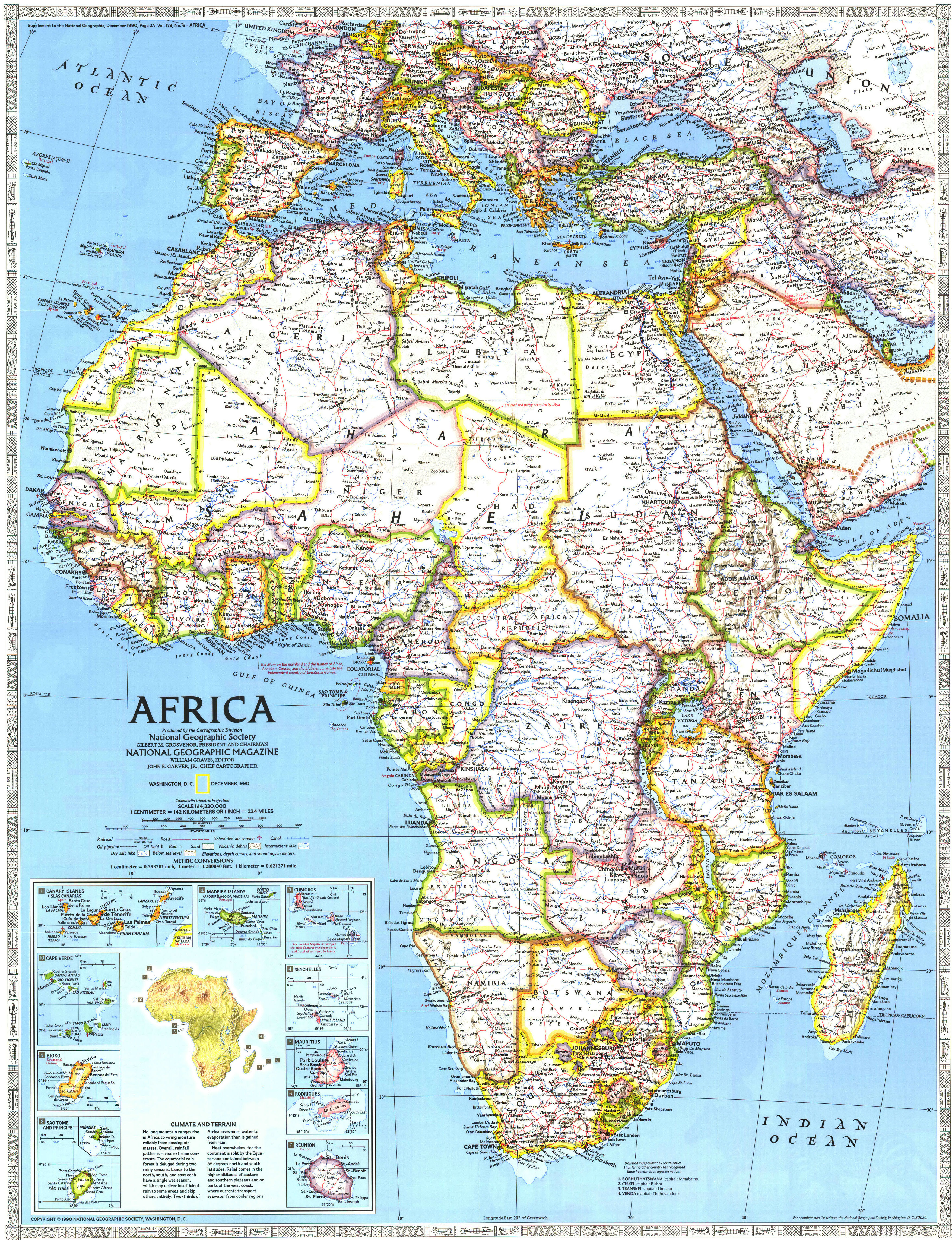
National Geographic’s Map of Africa – AD 1990 – (6MB)
16. Alright this is the real Africa of today (I just like the National Geographic map!)

Africa Today – (4MB)
